

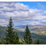
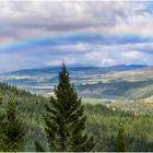
Whole rainbow over strath Tay
The beautiful rainbow stretched across the whole of Strath Tay and beneath it travelers drove on the A9 towards the Highlands and Inverness while the river Tay, famous for its salmon, flowed towards the former royal city of Perth. A brief moment to pause up here and enjoy the rainbow. But you are happy to accept a little rain.
Panorama from ten portrait format pictures-
Full screen recommended
"The A9 is a major road in Scotland running from the Falkirk council area in central Scotland to Scrabster Harbour, Thurso in the far north, via Stirling, Bridge of Allan, Perth and Inverness. At 273 mi (439 km), it is the longest road in Scotland and the fifth-longest A-road in the United Kingdom. Historically it was the main road between Edinburgh and John o' Groats, and has been called the spine of Scotland. It is one of the three major north–south trunk routes linking the Central Belt to the Highlands - the others being the A82 and the A90. The A9's origins lie in the military roads building programme carried out by General Wade in the 18th century to allow deployment of forces in key locations within the Highlands. At this time there was already an existing road between Perth and Dunkeld, and between 1727 and 1730 a roadway was constructed between Dunkeld in Perthshire and Inverness."
Ganzer Regenbogen über Strath Tay
Der wunderschöne Regenbogen streckte sich über das gesamte Strath Tay und unter ihm fuhren die Reisenden auf der A9 Richtung Hochland und Inverness, während der für seinen Lachse berühmte Fluß Tay ihnen entgegen Richtung der früheren Königsstadt Perth strömte. Ein kurzer Moment um hier oben inne zu halten und sich am Regenbogen zu erfreuen. Da nimmt man ein wenig Regen sehr gerne inkauf.
Panorama aus zehn Hochformatbildern.
Vollbild empfohlen
„Die A9 ist eine Hauptstraße in Schottland, die vom Gemeindegebiet Falkirk in Zentralschottland über Stirling, Bridge of Allan, Perth und Inverness nach Scrabster Harbour, Thurso im hohen Norden, führt. Mit einer Länge von 273 Meilen (439 km) ist sie die längste Straße in Schottland und die fünftlängste Landstraße im Vereinigten Königreich. Historisch gesehen war sie die Hauptstraße zwischen Edinburgh und John o' Groats und wird als Rückgrat Schottlands bezeichnet. Sie ist eine der drei großen Nord-Süd-Verbindungen Fernstraßen verbinden den Central Belt mit den Highlands – die anderen sind die A82 und die A90. Die Ursprünge der A9 liegen im Militärstraßenbauprogramm von General Wade im 18. Jahrhundert, um den Einsatz von Streitkräften an wichtigen Orten in den Highlands zu ermöglichen. Zu dieser Zeit gab es bereits eine Straße zwischen Perth und Dunkeld, und zwischen 1727 und 1730 wurde eine Straße zwischen Dunkeld in Perthshire und Inverness gebaut.
https://en.wikipedia.org/wiki/A9_road_(Scotland)
Before you travel the A9 read this. Life and death on the A9:
https://www.bbc.com/news/uk-scotland-26389280
Rainbow over Tay glen
Manuel Gloger
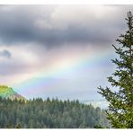
Rainbow_at Pine Cone Point
Manuel Gloger

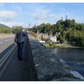
Gordon at...
Manuel Gloger
Commenti
10


Informazioni
| Sezioni | Viaggio: Perth and Kinross Natur: Berge Natur: Regenbögen |
| Cartelle | Schottland |
| Visto da | 6.295 |
| Pubblicato | |
| Lingua |

|
| Licenza |
Exif
| Fotocamera | NIKON D500 |
| Obiettivo | AF-S DX VR Zoom-Nikkor 18-105mm f/3.5-5.6G ED |
| Diaframma | 8 |
| Tempo di esposizione | 1/160 |
| Distanza focale | 90.0 mm |
| ISO | 100 |
Hanno messo mi piace


Inserire la foto in un'altra pagina
Aggiungi il seguente link in un commento, una descrizione o un messaggio per inserire questa immagine.
Link copiato...
Clicca sul link e usa i tasti "Strg C" [Win] oppure "Cmd C" [Mac] per copiare il link.
Condividi su Messenger
Inserisci il seguente link nel campo commento della conversazione desiderata su Messenger utilizzando 'Incolla' per inviare questa immagine nel messaggio.
Link copiato...
Clicca sul link e usa i tasti "Strg C" [Win] oppure "Cmd C" [Mac] per copiare il link.
Mario Siotto 09/09/2023 8:37
Magnifique panorama de ce beau paysage accompagné d'un fantastique arc en cielAmitiés
Mario
Anne Berger 03/09/2023 16:43
Wunderschön in dem Format und der Regenbogen toppt hier natürlich.LG Anne
felipe Martínez Pérez 02/09/2023 16:21
Bella imagen.Gerd Frey 01/09/2023 15:58
sehr passend und sehr schön ins format gebracht.lg gerd
Ernst Erdle 01/09/2023 14:19
ein schöner blick in die schottische landschaft, durch den regenbogen noch verfeinertMarkus 4 01/09/2023 9:57
und jetzt in seiner ganzen Breite und Pracht.Ein Genuß
Habedieehre
Markus
Joachim Irelandeddie 01/09/2023 7:14
Ein herrliches Panorama das du hör mit diesem tollen Regenbogen gemacht hast! Auch die ausführlichen Infos zu der Straße sind wieder sehr gutLG eddie
Stefan Jo Fuchs 01/09/2023 7:10
Das wird ja imemr schöner!Um die A9 kommt man in Schotland nicht herum, warum auch, so viele schöne Orte, die sie streift!
lg stefan
Christian Villain 31/08/2023 23:26
Excellente et Superbe photo de ce vaste panoramaBravo !!!
LG Christian
Vitória Castelo Santos 31/08/2023 21:42
WUNDERBARES PANORAMA !!!!