

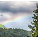
Rainbow over Tay glen
The rainbow spanned over the Glen with the river Tay and the A9. You can see where the A9 crosses the river. It´s amazing to see the blue eky on one side and the big rain clouds on the other side. Perthshire is bautiful and offers a lot to discover and see.
"The River Tay (Tatha in Gaelic) is the longest river in Scotland and the seventh longest in all of Great Britain. It is also considered to be the river with the largest catchment area in Great Britain. The river rises as the River Connonish at the foot of Ben Lui, barely 30 km from Oban and thus the west coast of Scotland. It then flows through Loch Dochhart, Loch Lubhair and Loch Tay under the name of River Fillan and as Dochart. Actually, the river is only named after the outflow from Loch Tay near Tay. As the Tay, it then flows to its lowest point near Perth, where it is practically already under the influence of the tides. Ultimately, the south of Dundee flows into the Firth of Tay and finally into the North Sea. The west-east distance of the Tay in Scotland is 193 km. It flows from a peak height of 560 meters above sea level to 0 meters above sea level."
Der Regenbogen erstreckte sich über das Glen mit dem Fluss Tay und der A9. Sie können sehen, wo die aA9 den Fluss überquert. Es ist erstaunlich, auf der einen Seite den blauen Himmel und auf der anderen Seite die großen Regenwolken zu sehen. Perthshire ist wunderschön und bietet viel zu entdecken und zu sehen.
" Der Fluss Tay (gälisch Tatha) ist der längste Fluss in Schottland und der siebtlängste in ganz Großbritannien. Außerdem gilt er als in Großbritannien als der Fluss mit dem größten Einzugsgebiet. Der Fluss entspringt als River Connonish am Fuß des Ben Lui, kaum 30km von Oban und damit der Westküste Schottlands entfernt. Er durchfließt danach unter den Namen River Fillan und als Dochart den Loch Dochhart, Loch Lubhair und Loch Tay. Eigentlich nennt sich der Fluss dann erst ab dem Abfluss aus dem Loch Tay bei Tay. Als Tay fließt der dann bis zu seinem niedrigsten Punkt bei Perth und liegt dort praktisch schon unter Einfluss der Gezeiten. Letztendlich mündet der südlich von Dundee in den Firth Of Tay und schließlich in die Nordsee. Die West-Ost Entfernung des Tay in Schottland beträgt 193km. Dabei fließt er von einer Spitzenhöhe von 560 Meter über NN auf O Meter Meereshöhe."
https://www.schottland-wegweiser.de/schottland_fluss_tay.html
https://taycountry.uk/
https://tayrivers.org/rivers-lochs/
https://en.wikipedia.org/wiki/A9_road_(Scotland)
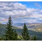
Rainbow_at Pine Cone Point
Manuel Gloger

Gordon at...
Manuel Gloger
Commenti
12


Informazioni
| Sezioni | Viaggio: Perth and Kinross Natur: Regenbögen |
| Cartelle | Schottland |
| Visto da | 5.978 |
| Pubblicato | |
| Lingua |

|
| Licenza |
Exif
| Fotocamera | NIKON D500 |
| Obiettivo | AF-S DX VR Zoom-Nikkor 18-105mm f/3.5-5.6G ED |
| Diaframma | 8 |
| Tempo di esposizione | 1/640 |
| Distanza focale | 40.0 mm |
| ISO | 100 |
Hanno messo mi piace


Inserire la foto in un'altra pagina
Aggiungi il seguente link in un commento, una descrizione o un messaggio per inserire questa immagine.
Link copiato...
Clicca sul link e usa i tasti "Strg C" [Win] oppure "Cmd C" [Mac] per copiare il link.
Condividi su Messenger
Inserisci il seguente link nel campo commento della conversazione desiderata su Messenger utilizzando 'Incolla' per inviare questa immagine nel messaggio.
Link copiato...
Clicca sul link e usa i tasti "Strg C" [Win] oppure "Cmd C" [Mac] per copiare il link.
Gerd Frey 01/09/2023 15:44
der regenbogen kanm ja zur rechten zeit!das tal kenne ich, nicht aber dienen standort.
lg gerd
Anne Berger 01/09/2023 14:39
Ein herrlicher Blick über diese Landschaft! Am Loch Tay habe ich schon zweimal übernachtet, die kleine Insel dort ist ein schönes Motiv.LG Anne
Ernst Erdle 01/09/2023 14:20
ach ja, da werden erinnerungen wachStefan Jo Fuchs 01/09/2023 7:19
der schöne Himmel, dieser zarte Regenbogen über der Landschaft - hinreißend schön!lg stefan
Hannes Gensfleisch 31/08/2023 20:53
Tja, hab' ich da einen Knick in der Optik oder warum hab' ich den Eindruck, dass er zwar sehr schön zwischen den Wolken hängt, aber weit weniger gebogen ist, als anderswo. Kann doch nicht sein, dass die Schotten auch an so etwas sparen. ;–)Vitória Castelo Santos 31/08/2023 19:50
Diese Aufnahme ist sehr schön!.LG Vitoria
Markus 4 31/08/2023 17:51
Nur die Straße stört diese Idylle, aber dafür kannst Du nix, die ist halt daHabedieehre
Markus
Joachim Irelandeddie 31/08/2023 17:01
Ein herrlicher Regenbogen der sich hier so weit über diese schöne Landschaft ausgebreitet hat. Sehr gut auch wieder deine Erläuterungen dazu!LG eddie