

* Wicklow Gap * upwards
I
R
L
In southern Wicklow Mountains National Park, between Tonelagee and Turlough Hill leads the R756 to Glendalough.
This area is moory and spring for (first of all) two small rivers: King River and Glendalough
.
.
this picture is taken 2 km below Wicklow Gap, Glendalough River
.
handsfree - HDR from 2, made to B&W and smaller - for fc ....
.
.
.
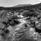
other side, downwards: 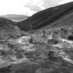
* Wicklow Gap * - downwards
BGW-photo
so sorry, google.maps doesn't provide exact data for this spot, but there it is:
http://maps.google.de/maps?q=53.024561,-6.363101&ll=53.023896,-6.361095&spn=0.004917,0.009645&num=1&t=h&z=17
for our fans of Irish Music: http://www.wicklowtrad.com/
Ireland 2012
Commenti
12


Informazioni
| Sezioni | Spezial: Monochrome Fine Art Viaggio: County Wicklow Digiart: HDRI & TM |
| Cartelle | * England, Ireland * |
| Visto da | 4.594 |
| Pubblicato | |
| Lingua |

|
| Licenza |
Hanno messo mi piace

Inserire la foto in un'altra pagina
Aggiungi il seguente link in un commento, una descrizione o un messaggio per inserire questa immagine.
Link copiato...
Clicca sul link e usa i tasti "Strg C" [Win] oppure "Cmd C" [Mac] per copiare il link.
Condividi su Messenger
Inserisci il seguente link nel campo commento della conversazione desiderata su Messenger utilizzando 'Incolla' per inviare questa immagine nel messaggio.
Link copiato...
Clicca sul link e usa i tasti "Strg C" [Win] oppure "Cmd C" [Mac] per copiare il link.
Joachim Irelandeddie 27/10/2015 14:52
Eine sehr gute s/w-Aufnahme hast du hier gemacht! Sieht sehr schön aus so als Langzeitbelichtung! Die Wicklow-Mountains sind herrlich, da hat es uns auch immer sehr gut gefallen!lg eddie
BRYAN CRUTE 23/11/2013 17:02
Looks as impressive in B&WRegards
Bryan
jah.picture Photography 06/09/2013 19:20
sehr gut!photograf 02 13/10/2012 12:33
ganz stark in dieser s/ bearbeitung...aber auch sehr schön aufgenommen vorher
lg
ha-jü
Jakob F. 02/10/2012 9:48
Ach ja, in den Wicklow Mountains war ich auch schon mal, da kommen schöne Erinnerungen hoch ...VG Jakob
Cobrak 29/09/2012 2:27
Bellissima..!Roland Krinner 29/09/2012 0:21
Long Exposure in s/w mag ich mittlerweile auch sehr gern. Es soll im nächsten Jahr auch Irland gehen ;-)Freu mich schon
LG
BGW-photo 28/09/2012 23:17
ich danke Euch ganz herzlich für die Kommentare!@ Kurt: ruhiges Hocken auf'm dicken Stein - und die Kamera auf den Knien geht auch für 3 Bilder ;-)
@ Jürgen: macht nichts, Schuhe vorher ausziehen ;-)
@ Volker & Venta: cordially thanks! exactly that was my feeling, as the water flowed towards me ...
Bernd
Jürgen Leuffen 28/09/2012 21:39
geiles Pic Bernd-ich hoffe du hattest keine nassen Füßegr Jürgen
kwolf191 28/09/2012 20:34
Coole Aufnahme ! Wunderschön die Bewegung des Wassers, man kann gar nicht wegsehen..! Und handsfree - Deine Ruhe hätte ich gern ! lg Kurtdreamer 07 28/09/2012 20:02
wunderschön,Chapeau**LG dreamer
KHMFotografie 28/09/2012 19:46
.... eine starke Landschaftsaufnahme, bernd..... und in SW..... kommt das super rüber+++++LG. kalle